

The Seaport' s Origin
Throughout its history, persistent and often unpredictable change has remained the one constant in the South Street Seaport Historic District. Originally situated at the outer edge of the port, the District became a vital section of the port’s core as the city and harbor region expanded in population, geographical size, and economic activity. In the half century between the War of 1812 and the Civil War, the junction of South and Fulton Streets was at the very heart of the port, a crossroads whose daily transactions and movements were felt throughout the nation and the world.
Merchants, seamen, longshoremen, market vendors, transit workers, artisans, restaurateurs, hotel workers, immigrants, commuters, consumers, and others converged and mingled here. In the late 19th and 20th centuries, this crossroads became secondary and then marginal once more, as the center of port activity shifted west to the Hudson River waterfront and then to Newark Bay. Today the District exists as museum, mall, sightseeing stop for tourists, and loft space for small businesses and residents. But the neighborhood’s past surfaces and intrudes everywhere.
Timeline
1624 First European colonists, sponsored by Dutch West India Company, arrive in New Netherland. First primitive dock constructed in East River.
1647 Peter Stuyvesant becomes governor. Isaac Allerton constructs great warehouse near Peck Slip, in the countryside beyond the town limits. By this date, the original East River shoreline (now Pearl Street) is known as “the Strand;” it remains the waterfront and the center of commercial activity until Water Street emerges at the end of the century.
1648 First stable pier in the city, rock fill with timber cribbing, completed at Pearl and Broad Streets, on the East River.
1664 British take possession of New Netherland; rename city and province after James, Duke of York, later James II.

In the early 19th century, the Port of New York was booming, and South Street was known as the Street of Ships.
1675-76 Great Dock built between Whitehall Slip and Coenties Slip.
1686-94 City begins to grant land to East River waterline, on condition that grantees build street or wharf there; this shoreline extension becomes Water Street.
1719 City grants lots from present Peck Slip to Fulton Street.
1719-22 Gerardus Beekman receives first water lot grant east of Pearl Street between present Fulton and Beekman Streets, on which he builds a public slip, Beekman Slip.
1737 Merchant Benjamin Peck secures permission to build a wharf and waterfront land from the city; area becomes Peck Slip.
1774 New York Tea Party (April 22): following Boston’s lead, New Yorkers dump tea from the ship London into harbor.
1776 August 29-30. Under cover of night and fog, George Washington evacuates 9,000 Continental Army soldiers from the ferry steps in Brooklyn to Peck Slip area after defeat in the Battle of Brooklyn, thereby allowing the Revolutionary War to continue.
1784 Water Street is extended to Corlears Hook.
1793 Peter Schermerhorn consolidates Beekman Slip water lots.
1795 Common Council orders creation of a new street, 70 feet wide, around the perimeter of the island. This becomes South Street.
1795 New York becomes leading American port, surpassing Philadelphia’s import and export volume for the first time.
1807 Beekman estate offers land for use as public market (site of future Fulton Market); acquisition authorized by State Legislature (1817). Beekman Slip landfill to South Street begun.

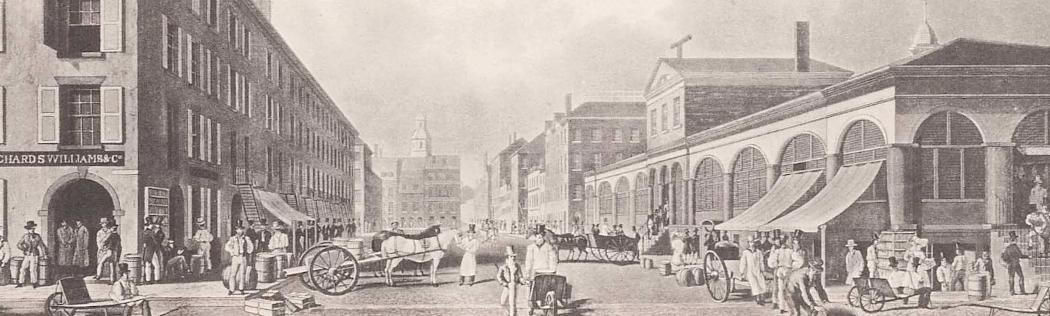
In 1834, artist William James Bennett made this view of Schermerhorn Row and the Fulton Market. Of all the buildings in this picture, only Schermerhorn Row (left side) remains today.
1810-12 South Street becomes city’s waterfront, from the Battery to former Beekman Slip. Schermerhorn Row is constructed. Common Council orders Peck Slip filled in to Front Street.
1812-15 War of 1812. Port participates through privateering and shipbuilding.
1816 Fulton Street (incorporating Partition Street, Fair Street, and Beekman Slip) is named in honor of Robert Fulton (d. 1815).
1817-25 Erie Canal opens in stages, starting in 1820, significantly enhancing the Port’s economy.
1822 Fulton Market opens at Pearl Street and Maiden Lane. East wing becomes fish market.
1835 Great Fire (Dec. 15-16) destroys 674 lower Manhattan buildings. Burling Slip is filled in.
1842 Abraham Sweet’s restaurant reputedly first opens at 8 Fulton Street.
1844 Beginning of clipper ship era: Houqua, first streamlined ship, designed by Capt. Nathaniel B. Palmer for China trade, launched in New York for A.A. Low & Brothers of Burling Slip.
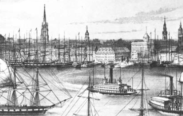
Brooklyn-bound ferries can be seen in this detail of an 1849 print, “View of New York from Brooklyn Heights” by Currier.
1849 California gold rush; many “forty niners” embark from South Street.
1870 Board of Docks reports that the busiest port activity has shifted to the area between Pier 1 and West 12th Street on the Hudson River.
1882 Thomas Edison’s 257 Pearl St. generating station, first central electric-light power plant in the world, begins operation: Seaport District becomes first commercial area ever with electric light.
1883 Brooklyn Bridge, under construction since 1870, opens May 24.
1913 Seamen’s Church Institute opens Seamen’s Home at 25 South Street. 1930 Sloppy Louie’s Restaurant opens, 92 South Street.
1962 Widening of 13-block stretch on Water and Pearl Streets completed; called the “most significant traffic improvement in the financial district since the turn of the century.” Demolition of buildings contributes to dispersion of old coffee and roasting district.
1965 Landmarks Preservation Commission established to protect city’s historically and architecturally valuable sites.

1966 City Planning Commission issues Lower Manhattan Plan, calling for public overhaul
of piers and blighted areas, creation of recreational spaces, and residential and business development in Manhattan south of Canal Street. National Historic Preservation Act prompts conservation and rehabilitation of historic urban waterfronts.
1967 South Street Seaport Museum chartered, with Peter Stanford as its first president.
1968 Landmarks Preservation Commission designates Schermerhorn Row Block and Baker, Carver & Morrell Building as Historic Landmarks.
1971 Schermerhorn Row Block approved for National Register of Historic Places. South Street Seaport District approved for National Register of Historic Places.
1973-74 Con Edison transformer station replaces two of Jasper Ward’s 1806 counting- houses on Peck Slip; wall mural of Brooklyn Bridge created by artist Richard Haas.

Schermerhorn Row, ca. 1970
1974 New York State purchases the Schermerhorn Row Block for the site of the State Maritime Museum.
1981 City signs revised lease with South Street Seaport Museum.
1989 An additional block, bounded by Peck Slip, Pearl, Water, and Dover Streets added to the South Street Seaport Historic District.
1991 New Seamen’s Church Institute opens at 241 Water Street.
1993 Plan for Lower Manhattan, a public-private project for area south of Chambers Street, announced. Goals include refurbishing of waterfront between Wall Street and the Seaport, and the creation of a continuous esplanade around Lower Manhattan.
1995 New York City renegotiates lease with the South Street Seaport Museum and removes the Museum from controlling the city’s non-Museum properties.

South Street Seaport today
1996 Pier 9 demolished by Economic Development Corporation.
1997 East River bikeway/walkway, an EDC project funded by the Federal Intermodal Surface Transportation Efficiency Act (ISTEA), opens.
1998 Sloppy Louie’s restaurant closes.
1999 EDC deactivates Pier 15 and makes plans to demolish it. Community Board 1 leads successful effort to gain approval from the state Dept. of Environmental Conservation that the pier will be rebuilt at later date.
2001 EDC demolishes structures on Piers 13 and 14
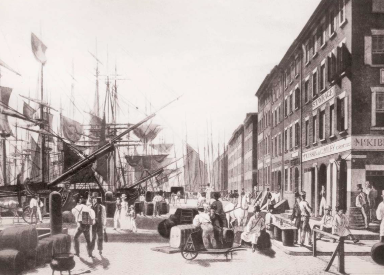
19th century water- front scene, looking south on South Street.
2002 EDC selects Yarrow LLC to develop significant residential properties on Front Street with sensitivity to history and architecture.
2003 City Council votes unanimously to downzone 10 blocks of historic district from no height restrictions to height restriction of 120 feet. South Street Seaport Museum opens 30,000 square foot, $22-million complex inside the buildings of Schermerhorn Row. Pier 15 demolition is completed.
2004 General Growth Properties takes over Rouse Company’s lease of Seaport properties.
2005 Lower Manhattan Development Corporation earmarks $150 million to fund elements of the City’s East River Waterfront plan. Fulton Fish Market moves to the Bronx.
2006 LMDC allocates funds for redevelopment of Burling Slip and Titanic Park. SeaportSpeaks charrette is convened.
2006 Historic Front Street opens; 11 new or renovated properties developed by Yarrow Two LLC, a company comprised of the principals of The Durst Organization and Zuberry Associates LLC.
2010 Imagination Playground, designed by David Rockwell, opens in Burling Slip.
2011 Newly rebuilt 50,000-square-foot Pier 15 opens, designed by SHoP Architects; features open lawns, planting beds, wooden benches and sets of steps leading down to the water. Formerly controlled by the South Street Seaport Museum, Pier 15 now controlled by NYC Economic Development Corporation.
2011 The Howard Hughes Corporation replaces General Growth Properties as leaseholder of the Seaport Marketplace.
2011 Multi-year renovation and reconstruction of Brooklyn Bridge and Brooklyn Bridge ramps begins; ongoing as of 2017.
2012 Superstorm Sandy devastates Seaport and environs; South Street Seaport Museum suffers $20+ million damage; first-floor units in Seaport under 5’ - 7' of water.
2012 Peck Slip Post Office closes; moves to smaller footprint on John Street.
2014 Howard Hughes Corporation begins demolition of Pier 17; after demolition is completed in 2015, begins construction of a new Pier 17, designed by SHoP Architects; projected opening 2018.
2015 Peck Slip School, PS 343, opens on the site of the former Peck Slip Post Office.
2015 After fierce opposition from the community and historic preservation organizations, Howard Hughes Corporation drops plans for a 494-foot tower on the site of the former New Market Building.
2016 iPic Theater, an “upscale cinema chain with plush seating, gourmet light bites & cocktails, plus in-theater service,” opens in the former Fulton Market Building.
2016 Jerry Driscoll Walk re-opens after being closed and neglected for five years during Brooklyn Bridge Ramp reconstruction.
2016 The South Street Seaport Museum's barque Peking leaves Pier 16 for Hamburg, Germany, to undergo restoration and be part of the Stiftung Hamburg Maritime Museum.
2016 The South Street Seaport Museum’s flagship, the iron-hulled Wavertree, returns to Pier 16 after a complete restoration.